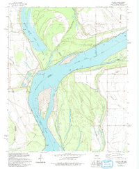
1981 Map of Council
USGS Topo · Published 1991About this map
The Mississippi River dominates this delta landscape, defining the state boundary between Arkansas and Mississippi. Along its meandering course, complex shifting terrain is visible in features like Buck Island and Peters Island, while numerous river landings such as Peters Landing and Lady Lee-Campbell Landing highlight the importance of waterborne transport to the local economy. The surrounding floodplain is crisscrossed by several bayous including Frenchmans Bayou and Fletcher Bayou, which drain the low-lying agricultural lands surrounding the small settlements of Peters and Commerce. The social life of these rural communities is anchored by local congregations at Peters Ch, Happy Ch, and Hopewell Ch. Large oxbow features like Midway Lake and Old River Lake serve as permanent reminders of the river's historic path through this border region.
Find a feature on this map
37 named features on this map. Tap any name to fly to it.
Don’t see what you’re looking for? This feature index may not catch every label — zoom into the map to look around manually.
Map Details
Editions of this 1981 Council Map
Other maps of this area

1908 · Hollywood
USGS Topo · 1:24,000

1913 · Hollywood
USGS Topo · 1:31,680

1931 · Horseshoe Lake
USGS Topo · 1:62,500

1939 · Clayton
USGS Topo · 1:62,500

1939 · Horseshoe Lake
USGS Topo · 1:62,500

1939 · Park Place
USGS Topo · 1:62,500

1939 · Latour
USGS Topo · 1:62,500

1948 · Helena
USGS Topo · 1:250,000

1950 · Helena
USGS Topo · 1:250,000

1954 · Horseshoe Lake
USGS Topo · 1:62,500