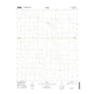
2016 Map of County Line
USGS Topo · Published 2016About this map
Yellow House Draw carves a subtle path through the high plains of the South Plains region, serving as the primary topographic feature in an area otherwise defined by its precise, rectilinear grid of rural roads. This landscape reflects the systematic agricultural development of West Texas, where the border between Bailey and Cochran counties is delineated by a simple east-west line. The small community of County Line sits near the southern edge of the sheet, while Silver Springs appears in the east. This 2016 survey documents the enduring layout of family-named local routes like Co RD 195 and Co RD 225 that connect the isolated farmsteads and watering points characteristic of this semi-arid terrain.
Find a feature on this map
32 named features on this map. Tap any name to fly to it.
Don’t see what you’re looking for? This feature index may not catch every label — zoom into the map to look around manually.
Map Details
Editions of this 2016 County Line Map
This is the sole edition of this map. No revisions or reprints were ever made.
Other maps of this area

1954 · Brownfield
USGS Topo · 1:250,000

1958 · Brownfield
USGS Topo · 1:250,000

1962 · Brownfield
USGS Topo · 1:250,000

1964 · Pep
USGS Topo · 1:24,000
1964 · Beck
USGS Topo · 1:24,000

1965 · Pettit
USGS Topo · 1:24,000
1968 · Bula
USGS Topo · 1:24,000
1968 · Upper White Lake
USGS Topo · 1:24,000

1969 · Enochs
USGS Topo · 1:24,000

1971 · Whiteface NW
USGS Topo · 1:24,000