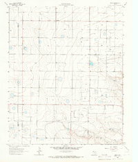
1964 Map of Beck
USGS Topo · Published 1966About this map
Deep within the High Plains of West Texas, this 1964 topographic study illustrates the agricultural and geologic character of the Bailey and Lamb County line. The landscape is defined by its subtle depressions and the prominent topographical feature of Bull Draw carving through the southern section. Small rural clusters like Friendship and the namesake Beck serve as the primary landmarks in an area otherwise characterized by wind-swept plains and scattered industrial activity. Evidence of local excavation is found at the Quarry and a Gravel Pit, pointing to the region's reliance on mineral resources during the mid-1960s. The map’s fine red dashed lines delineate selected fence lines, providing a rare look at the boundary-oriented nature of land use and ranching in this corner of Texas.
Find a feature on this map
7 named features on this map. Tap any name to fly to it.
Don’t see what you’re looking for? This feature index may not catch every label — zoom into the map to look around manually.
Map Details
Editions of this 1964 Beck Map
This is the sole edition of this map. No revisions or reprints were ever made.
Other maps of this area

1954 · Clovis
USGS Topo · 1:250,000

1954 · Brownfield
USGS Topo · 1:250,000

1958 · Brownfield
USGS Topo · 1:250,000

1958 · Clovis
USGS Topo · 1:250,000

1962 · Brownfield
USGS Topo · 1:250,000

1962 · Needmore
USGS Topo · 1:24,000

1962 · Amherst
USGS Topo · 1:24,000

1962 · Sudan
USGS Topo · 1:24,000

1964 · Oklahoma Flat
USGS Topo · 1:24,000
1964 · Bull Lake
USGS Topo · 1:24,000