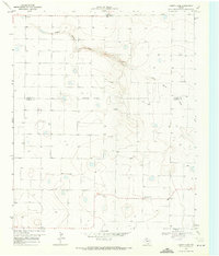
1974 Map of County Line
USGS Topo · Published 1977About this map
Yellow House Draw meanders across the High Plains of West Texas in this 1969 topographic study, defining the primary drainage for the agricultural landscape. The map highlights the rural community of County Line, situated at the border where Bailey Co and Cochran Co meet. This area, largely characterized by its topographic depressions and numerous water wells, shows a focused cluster of community life around the County Line Church. To the north, the presence of the Bula High Sch indicates the local educational hub of the era. The land use is reflected in features like the Gravel Pit and a regional Substation, illustrating the infrastructure supporting the isolated farmsteads and ranches of the Staked Plains during the late 1960s.
Find a feature on this map
8 named features on this map. Tap any name to fly to it.
Don’t see what you’re looking for? This feature index may not catch every label — zoom into the map to look around manually.
Map Details
Editions of this 1974 County Line Map
This is the sole edition of this map. No revisions or reprints were ever made.
Other maps of this area

1954 · Brownfield
USGS Topo · 1:250,000

1958 · Brownfield
USGS Topo · 1:250,000

1962 · Brownfield
USGS Topo · 1:250,000

1964 · Pep
USGS Topo · 1:24,000
1964 · Beck
USGS Topo · 1:24,000

1965 · Pettit
USGS Topo · 1:24,000
1968 · Bula
USGS Topo · 1:24,000
1968 · Upper White Lake
USGS Topo · 1:24,000

1969 · Enochs
USGS Topo · 1:24,000

1971 · Whiteface NW
USGS Topo · 1:24,000