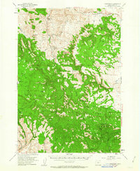
1951 Map of Courtrock
USGS Topo · Published 1963About this map
Malheur National Forest dominates much of this Oregon landscape, where mid-century ranching and timber interests defined the local economy. The tiny settlement of Hamilton and the Courtrock Post Office serve as the primary hubs for a sparsely populated region characterized by family-named landmarks and expansive high-country meadows. The presence of the Courtrock School suggests a community structure that supported isolated homesteads and forest workers during the early 1950s.
Find a feature on this map
40 named features on this map. Tap any name to fly to it.
Don’t see what you’re looking for? This feature index may not catch every label — zoom into the map to look around manually.
Map Details
Editions of this 1951 Courtrock Map
3 editions found
Other maps of this area

1932 · Dayville
USGS Topo · 1:125,000

1936 · Dayville
USGS Topo · 1:125,000

1940 · Mount Vernon
USGS Topo · 1:62,500

1940 · Aldrich Mtn.
USGS Topo · 1:62,500

1943 · Aldrich Mtn.
USGS Topo · 1:62,500

1943 · Mount Vernon
USGS Topo · 1:62,500

1949 · Long Creek
USGS Topo · 1:62,500

1950 · Ritter
USGS Topo · 1:62,500

1951 · Long Creek
USGS Topo · 1:62,500

1951 · Courtrock
USGS Topo · 1:62,500