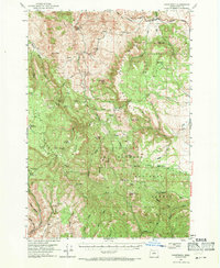
1951 Map of Courtrock
USGS Topo · Published 1971About this map
Malheur National Forest dominates this mid-century landscape in the North Fork John Day River drainage, revealing a pattern of isolated settlements and upland grazing. The small community of Hamilton serves as a primary reference point in the north, while the presence of the Courtrock PO indicates the site of a rural post office that once served this remote section of Grant County. The topography is defined by prominent volcanic and erosional landmarks like Courthouse Rock, China Peak, and the uniquely named Lost Boy Butte. High-elevation clearings such as McGarr Meadows and Petre Meadows suggest the historical importance of seasonal livestock range. Water resources are primarily represented by the branching drainages of Cottonwood Creek and Long Creek, which provided the necessary water for the homesteads and small Sch facilities scattered through the valleys.
Find a feature on this map
50 named features on this map. Tap any name to fly to it.
Don’t see what you’re looking for? This feature index may not catch every label — zoom into the map to look around manually.
Map Details
Editions of this 1951 Courtrock Map
3 editions found
Other maps of this area

1932 · Dayville
USGS Topo · 1:125,000

1936 · Dayville
USGS Topo · 1:125,000

1940 · Mount Vernon
USGS Topo · 1:62,500

1940 · Aldrich Mtn.
USGS Topo · 1:62,500

1943 · Aldrich Mtn.
USGS Topo · 1:62,500

1943 · Mount Vernon
USGS Topo · 1:62,500

1949 · Long Creek
USGS Topo · 1:62,500

1950 · Ritter
USGS Topo · 1:62,500

1951 · Long Creek
USGS Topo · 1:62,500

1951 · Courtrock
USGS Topo · 1:62,500