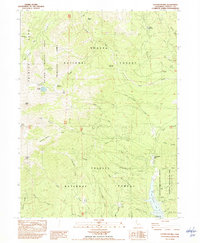
1982 Map of Covington Mill
USGS Topo · Published 1982About this map
Covington Mill and the Heath Ranch anchor the human footprint of this high-elevation landscape, where the waters of the Stuart Fork and Swift Creek drain toward the northern reach of Clair Engle Lake. The terrain is characterized by the high peaks of the Alps, including the prominent Gibson Peak and Granite Peak. A Hydraulic Mine near the upper reaches of Creek suggests the era's lingering mining legacy, while recreational development is visible through the Alpine View Campground and Hayward Flat Campground along the lake's shoreline. Within the Shasta National Forest and Trinity National Forest, the map captures the overlap of protected wilderness and industrial history, from the high Trinity Alps Primitive Area to the Boat Ramp access points that mark the region's transition into a major water recreation destination.
Find a feature on this map
59 named features on this map. Tap any name to fly to it.
Don’t see what you’re looking for? This feature index may not catch every label — zoom into the map to look around manually.
Map Details
Editions of this 1982 Covington Mill Map
This is the sole edition of this map. No revisions or reprints were ever made.
Other maps of this area

1886 · Shasta
USGS Topo · 1:250,000

1890 · Red Bluff
USGS Topo · 1:250,000

1894 · Red Bluff
USGS Topo · 1:250,000

1894 · Shasta
USGS Topo · 1:250,000

1913 · Weaverville
USGS Topo · 1:125,000

1923 · Sawyers Bar
USGS Topo · 1:125,000

1931 · Etna
USGS Topo · 1:96,000

1934 · Etna
USGS Topo · 1:125,000

1948 · Weed
USGS Topo · 1:250,000

1950 · Weed
USGS Topo · 1:250,000