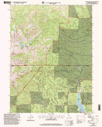
1998 Map of Covington Mill
USGS Topo · Published 2003About this map
Covington Mill and the Bowerman Barn Site occupy the lower elevations of this high-altitude landscape where the Stuart Fork meets the northern reaches of Trinity Lake. The area is defined by the steep transitions between the Trinity Alps Wilderness and the active recreation and resource zones of the Shasta-Trinity National Forests. Mining history is evidenced by a Hydraulic Mine near Pansy Gulch and the Diener Mine to the south, while the timber and ranching legacy persists at Heath Ranch. Numerous high-alpine water bodies, including Granite Lake, Gibson Lake, and Seven Up Lake, drain through a complex network of gulches and creeks like Swift Creek and Greenhorn Creek. Established campgrounds such as Alpine View and Hayward Flat signify the late-20th-century shift toward a recreation-based economy centered on the reservoir and wilderness access points.
Find a feature on this map
70 named features on this map. Tap any name to fly to it.
Don’t see what you’re looking for? This feature index may not catch every label — zoom into the map to look around manually.
Map Details
Editions of this 1998 Covington Mill Map
This is the sole edition of this map. No revisions or reprints were ever made.
Other maps of this area

1886 · Shasta
USGS Topo · 1:250,000

1890 · Red Bluff
USGS Topo · 1:250,000

1894 · Red Bluff
USGS Topo · 1:250,000

1894 · Shasta
USGS Topo · 1:250,000

1913 · Weaverville
USGS Topo · 1:125,000

1923 · Sawyers Bar
USGS Topo · 1:125,000

1931 · Etna
USGS Topo · 1:96,000

1934 · Etna
USGS Topo · 1:125,000

1948 · Weed
USGS Topo · 1:250,000

1950 · Weed
USGS Topo · 1:250,000