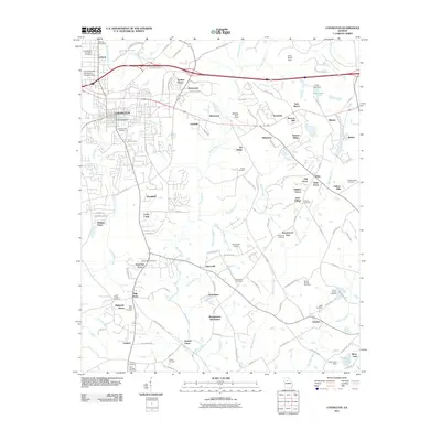
2011 Map of Covington
USGS Topo · Published 2011About this map
Covington and Oxford serve as the primary hubs in this Newton County landscape, where urban development meets a dense network of residential subdivisions and historical burial grounds. The geography is defined by the Alcovy River and its tributaries, including Cornish Creek and Wrights Creek, which carve through the terrain south of the Greer Lake Dam. The proliferation of modern neighborhoods like Settlers Grove, Brentwood, and Meadowwood Subdivision illustrates the suburban expansion of the early 21st century, yet the map remains deeply rooted in local history. Numerous family and community landmarks persist, from the Confederate Soldiers Cemetery in the northwest to the rural settlement of Hayston in the southeast. This survey preserves the locations of vital local sites such as the Windy Hill Airport, Morgan Farm Field, and the Troy University East Atlanta Covington Site, documenting a period of transition where traditional agricultural spaces are increasingly woven into the fabric of a growing metropolitan corridor.
Find a feature on this map
120 named features on this map. Tap any name to fly to it.
Don’t see what you’re looking for? This feature index may not catch every label — zoom into the map to look around manually.
Map Details
Editions of this 2011 Covington Map
This is the sole edition of this map. No revisions or reprints were ever made.
Other maps of this area

1896 · Monroe
USGS Topo · 1:125,000

1953 · Athens
USGS Topo · 1:250,000

1958 · Athens
USGS Topo · 1:250,000

1959 · Athens
USGS Topo · 1:250,000

1963 · Athens
USGS Topo · 1:250,000

1964 · Stewart
USGS Topo · 1:24,000

1964 · Worthville
USGS Topo · 1:24,000

1964 · Porterdale
USGS Topo · 1:24,000

1964 · Covington
USGS Topo · 1:24,000
1964 · Milstead
USGS Topo · 1:24,000