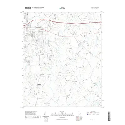
2020 Map of Covington
USGS Topo · Published 2020About this map
Covington serves as the focal point of this Newton County landscape, situated where modern development meets the historic agricultural roots of the Georgia Piedmont. The town's layout is anchored by the Newton County Judicial Center and Covington City Cem, while the CSX railroad corridor traces the transition from the municipal center to the outlying rural settlements. To the south and east, the Alcovy River and its tributaries, including Wrights Cr and Hurricane Cr, carve a winding path through the terrain. This topography reveals a deep-seated community history preserved in numerous burial grounds and small hamlets like Starrsville and Dixie. Genealogists may find value in the specific placement of the Confederate Soldiers Cem in nearby Oxford, and the various family-named landmarks like the Adams Cem and Rakestraw Cem that dot the countryside between small private airfields like Windy Hill Airport.
Find a feature on this map
235 named features on this map. Tap any name to fly to it.
Don’t see what you’re looking for? This feature index may not catch every label — zoom into the map to look around manually.
Map Details
Editions of this 2020 Covington Map
This is the sole edition of this map. No revisions or reprints were ever made.
Other maps of this area

1896 · Monroe
USGS Topo · 1:125,000

1953 · Athens
USGS Topo · 1:250,000

1958 · Athens
USGS Topo · 1:250,000

1959 · Athens
USGS Topo · 1:250,000

1963 · Athens
USGS Topo · 1:250,000

1964 · Stewart
USGS Topo · 1:24,000

1964 · Worthville
USGS Topo · 1:24,000

1964 · Porterdale
USGS Topo · 1:24,000

1964 · Covington
USGS Topo · 1:24,000
1964 · Milstead
USGS Topo · 1:24,000