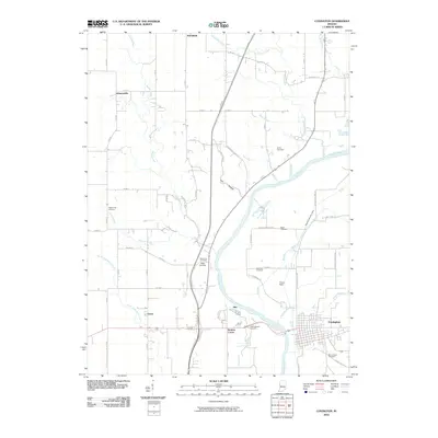
2010 Map of Covington
USGS Topo · Published 2010About this map
The Wabash River carves a diagonal path through this landscape, defining the western edge of Covington and separating the town from the agricultural stretches of the county. This 2010 survey highlights a distribution of burial grounds that mark the region's long settlement history, including Mount Hope Cemetery on the southern edge of town and the more isolated Gopher Hill Cemetery and Baltimore Cemetery to the west. Local landmarks like Fulton Field and small clusters such as Romine Corner and Foster reflect the enduring rural character of the area. Further north, the terrain is marked by numerous watercourses such as Chesapeake Creek and Redwood Creek that feed into the Wabash, alongside the distinctive ridge of Browns Hill. The map provides a detailed view of the local road grid, where historic routes like S Coal Hollow Rd and S Gobblers Knob Rd intersect with modern thoroughfares.
Find a feature on this map
62 named features on this map. Tap any name to fly to it.
Don’t see what you’re looking for? This feature index may not catch every label — zoom into the map to look around manually.
Map Details
Editions of this 2010 Covington Map
This is the sole edition of this map. No revisions or reprints were ever made.
Other maps of this area

1899 · Danville
USGS Topo · 1:62,500

1900 · Danville
USGS Topo · 1:62,500

1933 · Hoopeston
USGS Topo · 1:48,000

1938 · Hoopeston
USGS Topo · 1:62,500

1950 · Danville SE
USGS Topo · 1:24,000

1950 · Danville NE
USGS Topo · 1:24,000

1951 · Danville NE
USGS Topo · 1:24,000

1951 · Danville SE
USGS Topo · 1:24,000

1953 · Danville
USGS Topo · 1:250,000

1955 · Danville
USGS Topo · 1:250,000