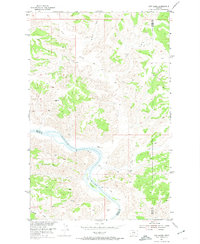
1954 Map of Cow Island
USGS Topo · Published 1974About this map
Missouri River waters wind through this mid-century survey of the Montana Breaks, a landscape defined by sharp coulees and remote family outposts. The Kip Homestead stands as a lonely marker of human settlement on the north bank, positioned near the significant bend that holds Cow Island. This landform historically served as a critical crossing point and steamboat landing during the height of river travel, though by the 1950s, the terrain was primarily accessed by a network of rugged paths like the Jeep Trail.
Find a feature on this map
13 named features on this map. Tap any name to fly to it.
Don’t see what you’re looking for? This feature index may not catch every label — zoom into the map to look around manually.
Map Details
Editions of this 1954 Cow Island Map
3 editions found
Other maps of this area

1943 · Landusky
USGS Topo · 1:125,000

1954 · Cow Island
USGS Topo · 1:24,000

1954 · Baker Monument
USGS Topo · 1:24,000

1954 · Sturgeon Island
USGS Topo · 1:24,000

1954 · Grand Island
USGS Topo · 1:24,000

1954 · Lewistown
USGS Topo · 1:250,000

1959 · Lewistown
USGS Topo · 1:250,000

1971 · Crazyman Coulee
USGS Topo · 1:24,000
1971 · John Coulee
USGS Topo · 1:24,000
1971 · Shetland Divide
USGS Topo · 1:24,000