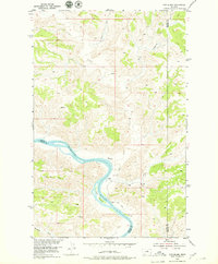
1954 Map of Cow Island
USGS Topo · Published 1979About this map
Missouri River bluffs and the rugged breaks of the Montana badlands define this mid-century landscape at the intersection of Blaine, Fergus, and Phillips counties. The area is dominated by the winding river channel and the prominent Cow Island, a site of significant historical activity along the upper Missouri. Evidence of local habitation is sparse but specific, including the Kip Homestead situated near a sharp bend in the river and a designated Landing downstream. The terrain is deeply incised by numerous seasonal drainages such as Squaw Creek, Cabin Creek, and Bull Creek, which carve through the high plains toward the river valley. A singular Jeep Trail provides the primary overland access through the complex topography, connecting riverside features to the higher elevations near Snake Point.
Find a feature on this map
15 named features on this map. Tap any name to fly to it.
Don’t see what you’re looking for? This feature index may not catch every label — zoom into the map to look around manually.
Map Details
Editions of this 1954 Cow Island Map
3 editions found
Other maps of this area

1943 · Landusky
USGS Topo · 1:125,000

1954 · Cow Island
USGS Topo · 1:24,000

1954 · Baker Monument
USGS Topo · 1:24,000

1954 · Sturgeon Island
USGS Topo · 1:24,000

1954 · Grand Island
USGS Topo · 1:24,000

1954 · Lewistown
USGS Topo · 1:250,000

1959 · Lewistown
USGS Topo · 1:250,000

1971 · Crazyman Coulee
USGS Topo · 1:24,000
1971 · John Coulee
USGS Topo · 1:24,000
1971 · Shetland Divide
USGS Topo · 1:24,000