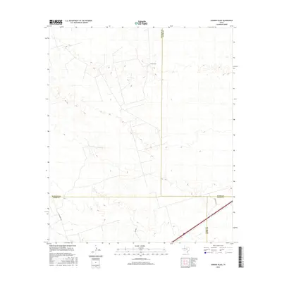
2016 Map of Cowden Place
USGS Topo · Published 2016About this map
Cowden Place anchors this section of the Permian Basin, where the boundaries of Winkler, Ector, Ward, and Crane counties converge. The landscape reflects the region's long-standing reliance on energy production and heavy industry, notably marked by the infrastructure of Altura Energy Ltd. While the terrain is characterized by the sparse, open expanses of West Texas, a network of industrial access routes and local connectors like Park Rd 41 and Glenn Allen Rd provides a detailed look at the rural transport system serving the area's oil and gas interests. This 2016 survey captures the intersection of traditional ranching geography and modern petroleum extraction, offering a precise view of property divisions and resource management in a highly productive corner of the state.
Find a feature on this map
8 named features on this map. Tap any name to fly to it.
Don’t see what you’re looking for? This feature index may not catch every label — zoom into the map to look around manually.
Map Details
Editions of this 2016 Cowden Place Map
This is the sole edition of this map. No revisions or reprints were ever made.
Other maps of this area

1954 · Pecos
USGS Topo · 1:250,000

1957 · Pecos
USGS Topo · 1:250,000

1964 · Metz
USGS Topo · 1:24,000

1964 · Red Lakes
USGS Topo · 1:24,000

1964 · Penwell SW
USGS Topo · 1:24,000

1968 · Monahans SE
USGS Topo · 1:24,000

1968 · Cowden Place
USGS Topo · 1:24,000

1968 · China Ranch
USGS Topo · 1:24,000

1969 · Monahans
USGS Topo · 1:24,000
1971 · Amburgey Ranch
USGS Topo · 1:24,000