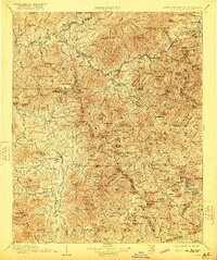
1907 Map of Cowee
USGS Topo · Published 1921About this map
Bryson and Franklin serve as the primary hubs in this turn-of-the-century survey, a period when the Southern Ry followed the winding course of the Tuckasegee River through the heart of the mountains. The map captures a landscape defined by its river-valley settlements and high mountain gaps, showing the early footprints of towns like Sylva, Cullowhee, and Waynesville. At this time, commerce and travel were tethered to water and rail, with Wests Mill and Dillsboro marking key points of local activity.
Find a feature on this map
208 named features on this map. Tap any name to fly to it.
Don’t see what you’re looking for? This feature index may not catch every label — zoom into the map to look around manually.
Map Details
Editions of this 1907 Cowee Map
5 editions found

Other maps of this area

1886 · Knoxville
USGS Topo · 1:125,000

1886 · Dahlonega
USGS Topo · 1:125,000

1886 · Walhalla
USGS Topo · 1:125,000

1888 · Pickens
USGS Topo · 1:125,000

1891 · Cowee
USGS Topo · 1:125,000

1892 · Dahlonega
USGS Topo · 1:125,000

1892 · Walhalla
USGS Topo · 1:125,000

1892 · Knoxville
USGS Topo · 1:125,000

1893 · Mt Guyot
USGS Topo · 1:125,000

1894 · Asheville
USGS Topo · 1:125,000