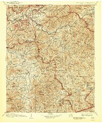
1907 Map of Cowee
USGS Topo · Published 1943About this map
The Qualla Indian Reservation and the high ridges of the Great Smoky Mountains anchor the northern reaches of this turn-of-the-century survey. Industry and commerce follow the narrow river valleys, where the Southern Railway winds through Sylva, Dillsboro, and Whittier along the Tuckasegee River. This era shows the region before the widespread establishment of national park boundaries, though the Pisgah National Forest and Nantahala National Forest are already significant presence on the landscape.
Find a feature on this map
160 named features on this map. Tap any name to fly to it.
Don’t see what you’re looking for? This feature index may not catch every label — zoom into the map to look around manually.
Map Details
Editions of this 1907 Cowee Map
5 editions found

Other maps of this area

1886 · Knoxville
USGS Topo · 1:125,000

1886 · Dahlonega
USGS Topo · 1:125,000

1886 · Walhalla
USGS Topo · 1:125,000

1888 · Pickens
USGS Topo · 1:125,000

1891 · Cowee
USGS Topo · 1:125,000

1892 · Dahlonega
USGS Topo · 1:125,000

1892 · Walhalla
USGS Topo · 1:125,000

1892 · Knoxville
USGS Topo · 1:125,000

1893 · Mt Guyot
USGS Topo · 1:125,000

1894 · Asheville
USGS Topo · 1:125,000