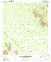
1979 Map of Cowlic
USGS Topo · Published 1980About this map
The Papago Indian Reservation landscape is defined by its wide desert basins and striking mountain ranges, as documented in this mid-1970s survey. The settlement of Cowlic sits in the west, marked by a cluster of infrastructure including Wells and a Cem, while to the southeast, the historic footprint of Vopolo Havoka (Site) lies near its contemporary counterpart, Vopolo Havoka. The topography is shaped by the drainage patterns of Fresnal Wash and Vamori Wash, which carve through the La Mori Valley.
Find a feature on this map
19 named features on this map. Tap any name to fly to it.
Don’t see what you’re looking for? This feature index may not catch every label — zoom into the map to look around manually.
Map Details
Editions of this 1979 Cowlic Map
2 editions found
Other maps of this area

1941 · Vamori
USGS Topo · 1:62,500

1941 · Sells
USGS Topo · 1:62,500

1943 · Sells
USGS Topo · 1:62,500

1943 · Fresnal
USGS Topo · 1:125,000

1943 · Vamori
USGS Topo · 1:62,500

1954 · Sonoyta
USGS Topo · 1:250,000

1956 · Nogales
USGS Topo · 1:250,000

1958 · Nogales
USGS Topo · 1:250,000

1959 · Nogales
USGS Topo · 1:250,000

1963 · Gu Oidak
USGS Topo · 1:62,500