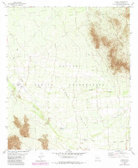
1979 Map of Cowlic
USGS Topo · Published 1984About this map
The Papago Indian Reservation landscape is defined by the high relief of the Artesa Mountains and the Alvarez Mts as they overlook the broad expanse of the Vamori Valley. This 1979 survey records the small settlement of Cowlic, situated near the confluence of Fresnal Wash and Vamori Wash. The map documents indigenous habitation and land use through the presence of both the current settlement of Vopolo Havoka and a nearby designated Vopolo Havoka (Site). Genealogical interest is found in the local Cem and various wells scattered across Sells Valley, marking reliable water points in a desert environment where seasonal drainage through Sells Wash and Baboquivari Wash shaped the movement of people and livestock.
Find a feature on this map
15 named features on this map. Tap any name to fly to it.
Don’t see what you’re looking for? This feature index may not catch every label — zoom into the map to look around manually.
Map Details
Editions of this 1979 Cowlic Map
2 editions found
Other maps of this area

1941 · Vamori
USGS Topo · 1:62,500

1941 · Sells
USGS Topo · 1:62,500

1943 · Sells
USGS Topo · 1:62,500

1943 · Fresnal
USGS Topo · 1:125,000

1943 · Vamori
USGS Topo · 1:62,500

1954 · Sonoyta
USGS Topo · 1:250,000

1956 · Nogales
USGS Topo · 1:250,000

1958 · Nogales
USGS Topo · 1:250,000

1959 · Nogales
USGS Topo · 1:250,000

1963 · Gu Oidak
USGS Topo · 1:62,500