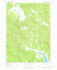
1964 Map of Cox Flat
USGS Topo · Published 1978About this map
Fremont National Forest dominates this landscape in southern Oregon, where the high-elevation terrain is defined by a network of drainage creeks and isolated springs. The map documents industrial activity in the mid-1960s, specifically at the Lucky Lass Mine and White King Mine, alongside numerous prospects that indicate the mineral exploration of the period. This area of Lake County reflects a transition from resource extraction to recreation, as evidenced by the established Thomas Creek Campground and Irishmans Campground. To the south, the Cottonwood Reservoir stands as a significant hydrological feature with its spillway elevation noted at 5072 feet. A single domestic footprint, Garrett Place, remains tucked along Thomas Creek, while the broader terrain of Cox Flat and surrounding ridges are traversed by a series of high-clearance jeep trails.
Find a feature on this map
28 named features on this map. Tap any name to fly to it.
Don’t see what you’re looking for? This feature index may not catch every label — zoom into the map to look around manually.
Map Details
Editions of this 1964 Cox Flat Map
4 editions found
Other maps of this area

1955 · Klamath Falls
USGS Topo · 1:250,000

1958 · Klamath Falls
USGS Topo · 1:250,000

1964 · Drews Reservoir
USGS Topo · 1:24,000

1964 · Cox Flat
USGS Topo · 1:24,000

1964 · Lakeview NW
USGS Topo · 1:24,000

1964 · Coleman Point
USGS Topo · 1:24,000

1964 · Cougar Peak
USGS Topo · 1:24,000

1964 · Shoestring Butte
USGS Topo · 1:24,000

1964 · Drews Gap
USGS Topo · 1:24,000

1964 · Clover Flat
USGS Topo · 1:24,000