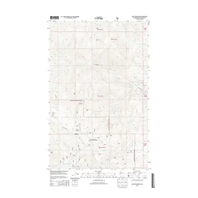
2014 Map of Coxit Mountain
USGS Topo · Published 2014About this map
Okanogan National Forest dominates this landscape in the northern cascades, where steep ridges and high-altitude basins form the headwaters of numerous mountain streams. The terrain is characterized by prominent peaks like Coxit Mtn and Cougar Mtn, separated by high crossings such as Angel Pass. This 2014 survey reveals a network of Forest Service infrastructure designed for access and recreation, notably at Salmon Meadows where the Salmon Meadows Campground is located. The presence of the isolated Woodpile Cabin and names like Deer Ridge and Woodpile Ridge speak to the area's history of backcountry management and forestry. Dozens of drainages, including Sinlahekin Cr, Isabel Cr, and Chute Cr, carve through the high country, illustrating the complex hydrology of the region before these waters descend toward the Okanogan Valley. The map provides a precise look at the forest road system, including the Sinlahekin Creek Rd, which serves as a primary artery through this rugged territory.
Find a feature on this map
81 named features on this map. Tap any name to fly to it.
Don’t see what you’re looking for? This feature index may not catch every label — zoom into the map to look around manually.
Map Details
Editions of this 2014 Coxit Mountain Map
This is the sole edition of this map. No revisions or reprints were ever made.
Other maps of this area

1906 · Chopaka
USGS Topo · 1:125,000

1954 · Okanogan
USGS Topo · 1:250,000

1956 · Loomis
USGS Topo · 1:62,500

1956 · Tiffany Mountain
USGS Topo · 1:62,500

1956 · Horseshoe Basin
USGS Topo · 1:62,500

1957 · Conconully
USGS Topo · 1:62,500

1958 · Okanogan
USGS Topo · 1:250,000
1980 · Blue Goat Mtn
USGS Topo · 1:24,000
1981 · Conconully East
USGS Topo · 1:24,000
1981 · Corral Butte
USGS Topo · 1:24,000