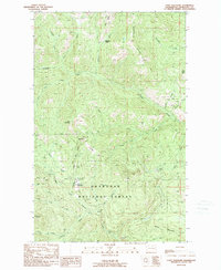
1989 Map of Coxit Mountain
USGS Topo · Published 1989About this map
Okanogan National Forest dominates this mountain landscape, which was documented during a series of field checks in the mid-1980s. The topography is defined by high-elevation peaks and ridges, including Coxit Mountain, Cougar Mtn, and the distinctive Twin Peaks. Drainage systems like the Sinlahekin Creek and Salmon Creek create deep valleys that historically dictated travel and seasonal settlement. Human presence is centered on recreation and resource management, with notable points such as Salmon Meadows, the Salmon Meadows Campground, and a Ski Lodge located near the headwaters of Meadow Creek. For those interested in back-country history, the map traces the Tiffany Lake Trail and identifies the remote Woodpile Cabin tucked near Woodpile Creek. The map also identifies industrial sites like the Gravel Pit along the South Fork Coxit Creek, showing how the land was used for mountain access and road maintenance.
Find a feature on this map
42 named features on this map. Tap any name to fly to it.
Don’t see what you’re looking for? This feature index may not catch every label — zoom into the map to look around manually.
Map Details
Editions of this 1989 Coxit Mountain Map
This is the sole edition of this map. No revisions or reprints were ever made.
Other maps of this area

1906 · Chopaka
USGS Topo · 1:125,000

1954 · Okanogan
USGS Topo · 1:250,000

1956 · Loomis
USGS Topo · 1:62,500

1956 · Tiffany Mountain
USGS Topo · 1:62,500

1956 · Horseshoe Basin
USGS Topo · 1:62,500

1957 · Conconully
USGS Topo · 1:62,500

1958 · Okanogan
USGS Topo · 1:250,000
1980 · Blue Goat Mtn
USGS Topo · 1:24,000
1981 · Conconully East
USGS Topo · 1:24,000
1981 · Corral Butte
USGS Topo · 1:24,000