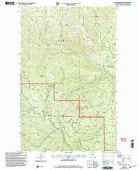
2001 Map of Coxit Mountain
USGS Topo · Published 2004About this map
Loomis State Forest and the Okanogan National Forest converge in this high-altitude landscape, where drainage patterns are defined by a network of steep canyons and ridges. Central to the area is Coxit Mountain, surrounded by the headwaters of Sinhahekin Creek, Coxit Creek, and Salmon Creek. The map documents a land managed primarily for timber and conservation at the start of the 21st century, showing limited human infrastructure beyond the Tiffany Lake Trail and scattered primitive structures like Woodpile Cabin.
Find a feature on this map
36 named features on this map. Tap any name to fly to it.
Don’t see what you’re looking for? This feature index may not catch every label — zoom into the map to look around manually.
Map Details
Editions of this 2001 Coxit Mountain Map
This is the sole edition of this map. No revisions or reprints were ever made.
Other maps of this area

1906 · Chopaka
USGS Topo · 1:125,000

1954 · Okanogan
USGS Topo · 1:250,000

1956 · Loomis
USGS Topo · 1:62,500

1956 · Tiffany Mountain
USGS Topo · 1:62,500

1956 · Horseshoe Basin
USGS Topo · 1:62,500

1957 · Conconully
USGS Topo · 1:62,500

1958 · Okanogan
USGS Topo · 1:250,000
1980 · Blue Goat Mtn
USGS Topo · 1:24,000
1981 · Conconully East
USGS Topo · 1:24,000
1981 · Corral Butte
USGS Topo · 1:24,000