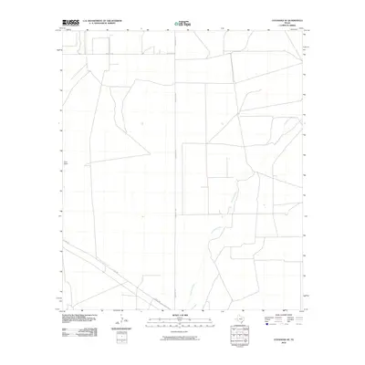
2010 Map of Coyanosa SE
USGS Topo · Published 2010About this map
Courtney Creek winds through this arid expanse of Pecos County, tracing a path across a landscape defined by ranching infrastructure and drainage patterns. The ephemeral waters of Cato Draw mark the western portion of the quadrangle, where the terrain gradually slopes toward the Pecos River basin. Human passage is represented by a geometric grid of rural roads, most notably Ranch Rd 1776 which bisects the map vertically, and the diagonal strike of N Hwy 285 in the southwest. This 2010 survey illustrates the modernization of West Texas transportation, where long-established ranch tracks like Mcintyre Rd meet state-maintained highways, facilitating movement across the Permian Basin's open scrubland.
Find a feature on this map
5 named features on this map. Tap any name to fly to it.
Don’t see what you’re looking for? This feature index may not catch every label — zoom into the map to look around manually.
Map Details
Editions of this 2010 Coyanosa SE Map
This is the sole edition of this map. No revisions or reprints were ever made.
Other maps of this area
1921 · Fort Stockton
USGS Topo · 1:62,500
1923 · Fort Stockton
USGS Topo · 1:62,500
1928 · Comanche Spring
USGS Topo · 1:125,000
1929 · Hovey
USGS Topo · 1:125,000
1931 · Barstow
USGS Topo · 1:125,000

1954 · Pecos
USGS Topo · 1:250,000

1954 · Fort Stockton
USGS Topo · 1:250,000

1957 · Pecos
USGS Topo · 1:250,000

1958 · Fort Stockton
USGS Topo · 1:250,000
1970 · Fort Stockton West
USGS Topo · 1:24,000