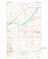
1965 Map of Coyote Rapids
USGS Topo · Published 1966About this map
The Columbia River carves a dramatic bend through this mid-century landscape, defined by the restricted operations of the Hanford Atomic Energy Commission Reservation. A sprawling network of the U S Govt Railroad serves the high-security installation, connecting facilities across the Cold Creek Valley. The terrain is marked by prominent basalt features like Gable Butte and Gable Mountain, rising above a floor of sand dunes and gravel pits. To the north, the Wahluke Slope overlooks the river's Coyote Rapids. This survey preserves the locations of several small company or support settlements, including Allard, Wahluke, and Riverland, along with infrastructure like the Vernita Bridge and the Yakima Barricade. The presence of the Hanford Ditch and numerous test wells reflects the intense hydrological and industrial management of this unique Cold War-era zone.
Find a feature on this map
39 named features on this map. Tap any name to fly to it.
Don’t see what you’re looking for? This feature index may not catch every label — zoom into the map to look around manually.
Map Details
Editions of this 1965 Coyote Rapids Map
2 editions found
Other maps of this area

1911 · Red Rock
USGS Topo · 1:62,500

1912 · Beverly
USGS Topo · 1:62,500

1915 · Prosser
USGS Topo · 1:125,000

1916 · Coyote Rapids
USGS Topo · 1:62,500

1917 · Pasco
USGS Topo · 1:125,000

1917 · Priest Rapids
USGS Topo · 1:62,500

1917 · Prosser
USGS Topo · 1:125,000

1923 · Corfu
USGS Topo · 1:62,500

1924 · Hanford
USGS Topo · 1:62,500

1948 · Emerson Nipple
USGS Topo · 1:24,000