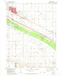
1971 Map of Cozad
USGS Topo · Published 1973About this map
The Platte River corridor dominates this central Nebraska landscape, defining a complex network of irrigation and historical transit. The city of Cozad sits at the heart of the valley, showing its layout from the High Sch and Hospital to the Cozad Municipal Airport. This 1971 field-checked survey highlights the critical role of water management in the region, tracing the Cozad Canal, Alfalfa Canal, and Thirtymile Canal as they support the agricultural economy. Parallel to the river, the Union Pacific railroad and the Emigrant (Approximate Location) Trail reflect the enduring path of transcontinental movement. Outside the city center, the map identifies small rural hubs like Darr and several numbered schoolhouses, including School No 29 and School No 66, which provide specific points of interest for genealogists and local historians studying the rural township structure of Dawson County.
Find a feature on this map
40 named features on this map. Tap any name to fly to it.
Don’t see what you’re looking for? This feature index may not catch every label — zoom into the map to look around manually.
Map Details
Editions of this 1971 Cozad Map
This is the sole edition of this map. No revisions or reprints were ever made.
Other maps of this area

1896 · Lexington
USGS Topo · 1:125,000

1899 · Lexington
USGS Topo · 1:125,000

1902 · Gothenburg
USGS Topo · 1:125,000

1954 · McCook
USGS Topo · 1:250,000

1955 · Grand Island
USGS Topo · 1:250,000

1957 · McCook
USGS Topo · 1:250,000

1957 · Grand Island
USGS Topo · 1:250,000

1958 · McCook
USGS Topo · 1:250,000

1958 · Grand Island
USGS Topo · 1:250,000

1962 · Lexington West
USGS Topo · 1:24,000