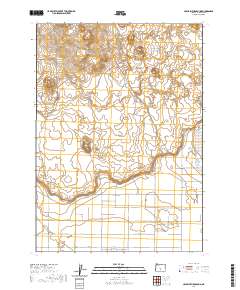
2020 Map of Crack In The Ground
USGS Topo · Published 2020About this map
The volcanic High Desert of Lake County is defined by the Crack in the Ground, an ancient volcanic fissure that cuts through the landscape north of the Christmas Lake Valley settlement. This 2020 survey illustrates the distinct transition between the high basaltic formations and the agricultural grid of the valley below. To the north, the Four Craters Lava Field and South Green Mtn dominate the volcanic terrain, while Reed Rock stands as a prominent landmark in the western section. The southern half of the map reveals a meticulously planned network of local roads with whimsical names like Honey Do Ln, Candy Ln, and N Star Ln, radiating from the core of the valley community near Christmas Lake. This geographic record captures the unique intersection of modern rural settlement and prehistoric geologic activity in central Oregon.
Find a feature on this map
34 named features on this map. Tap any name to fly to it.
Don’t see what you’re looking for? This feature index may not catch every label — zoom into the map to look around manually.
Map Details
Editions of this 2020 Crack In The Ground Map
This is the sole edition of this map. No revisions or reprints were ever made.
Other maps of this area

1955 · Crescent
USGS Topo · 1:250,000

1957 · Crescent
USGS Topo · 1:250,000

1958 · Crescent
USGS Topo · 1:250,000

1970 · Crescent
USGS Topo · 1:250,000

1981 · Hogback Butte
USGS Topo · 1:24,000

1981 · Thorn Lake
USGS Topo · 1:24,000

1981 · Lane Lake
USGS Topo · 1:24,000

1982 · Peters Creek Sink
USGS Topo · 1:24,000

1982 · Christmas Lake
USGS Topo · 1:24,000

1982 · Jacks Place
USGS Topo · 1:24,000