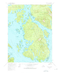
1951 Map of Craig A-3
USGS Topo · Published 1975About this map
Hydaburg stands as the primary cultural and residential center on the western coast of Prince of Wales Island, situated where the Sukkwan Strait meets the North Pass. This 1951 survey, annotated with hydrographic data from the early 1950s, reveals a landscape defined by an intricate network of waterways and timber-heavy island masses within the Tongass National Forest. The map documents the vital maritime orientation of the region, where travel and industry rely on passages like the Sukkwan Narrows and South Pass.
Find a feature on this map
54 named features on this map. Tap any name to fly to it.
Don’t see what you’re looking for? This feature index may not catch every label — zoom into the map to look around manually.
Map Details
Editions of this 1951 Craig A-3 Map
3 editions found

Other maps of this area

1948 · Craig A-4
USGS Topo · 1:63,360

1948 · Dixon Entrance D-2
USGS Topo · 1:63,360

1948 · Dixon Entrance D-4
USGS Topo · 1:63,360

1948 · Dixon Entrance D-3
USGS Topo · 1:63,360

1948 · Craig A-3
USGS Topo · 1:63,360

1948 · Craig A-2
USGS Topo · 1:63,360

1949 · Craig B-2
USGS Topo · 1:63,360

1949 · Craig B-3
USGS Topo · 1:63,360

1949 · Craig B-4
USGS Topo · 1:63,360

1951 · Craig B-2
USGS Topo · 1:63,360