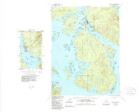
1951 Map of Craig A-3
USGS Topo · Published 1988About this map
Hydaburg stands as the primary settlement on this portion of Prince of Wales Island, situated along the eastern shore of Sukkwan Strait. This 1951 field-checked survey reveals a focused maritime economy, evidenced by the Seaplane Base and proximity to Saltery Pt. The detailed inset of the town site shows local infrastructure including a Church and a Water Tank, while the broader landscape is dominated by the intricate waterways of Cordova Bay and Hetta Inlet.
Find a feature on this map
67 named features on this map. Tap any name to fly to it.
Don’t see what you’re looking for? This feature index may not catch every label — zoom into the map to look around manually.
Map Details
Editions of this 1951 Craig A-3 Map
3 editions found

Other maps of this area

1948 · Craig A-4
USGS Topo · 1:63,360

1948 · Dixon Entrance D-2
USGS Topo · 1:63,360

1948 · Dixon Entrance D-4
USGS Topo · 1:63,360

1948 · Dixon Entrance D-3
USGS Topo · 1:63,360

1948 · Craig A-3
USGS Topo · 1:63,360

1948 · Craig A-2
USGS Topo · 1:63,360

1949 · Craig B-2
USGS Topo · 1:63,360

1949 · Craig B-3
USGS Topo · 1:63,360

1949 · Craig B-4
USGS Topo · 1:63,360

1951 · Craig B-2
USGS Topo · 1:63,360