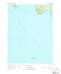
1948 Map of Craig A-5
USGS Topo · Published 1967About this map
Suemez Island and Baker Island dominate the northern margins of this 1948 survey, where the terrestrial edge of the Tongass National Forest meets the open Pacific Ocean. This coastal landscape is defined by the sharp transition from the steep elevations of the Alexander Archipelago to deep maritime waters, notably within the expanse of Bucareli Bay. The map provides a rare look at the outlying Forrester Island National Wildlife Refuge at Wolf Rock, illustrating the isolation of these island outposts before modern satellite mapping. Navigational landmarks like Cape Bartolome and Cape Felix stand as sentinel points for the mariners and fishermen who historically worked these waters, while smaller features like Arena Cove and Lontana Pt indicate the fine-grained topographical detail captured by photogrammetric methods in the late 1940s.
Find a feature on this map
13 named features on this map. Tap any name to fly to it.
Don’t see what you’re looking for? This feature index may not catch every label — zoom into the map to look around manually.
Map Details
Editions of this 1948 Craig A-5 Map
3 editions found
Other maps of this area

1948 · Craig A-4
USGS Topo · 1:63,360

1948 · Dixon Entrance D-5
USGS Topo · 1:63,360

1948 · Craig B-5
USGS Topo · 1:63,360

1948 · Craig A-5
USGS Topo · 1:63,360

1948 · Craig B-6
USGS Topo · 1:63,360

1948 · Dixon Entrance D-4
USGS Topo · 1:63,360

1949 · Craig B-4
USGS Topo · 1:63,360

1951 · Craig B-4
USGS Topo · 1:63,360

1951 · Dixon Entrance
USGS Topo · 1:250,000

1951 · Craig A-4
USGS Topo · 1:63,360