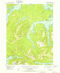
1951 Map of Craig B-2
USGS Topo · Published 1952About this map
Prince of Wales Island is dominated by deep glacial fjords and high peaks in this mid-century topographic record of the Tongass National Forest. The intricate coastline is defined by Polk Inlet and the Twelvemile Arm, creating a complex maritime landscape where transportation relied heavily on water routes and overland portages. Evidence of early 20th-century resource extraction and Indigenous history is preserved through labels for the Khayyam Mine (Aban'd) and the Old Kasaan Nat Mon, reflecting the area's transition from active mining and traditional habitation to federal management.
Find a feature on this map
57 named features on this map. Tap any name to fly to it.
Don’t see what you’re looking for? This feature index may not catch every label — zoom into the map to look around manually.
Map Details
Editions of this 1951 Craig B-2 Map
2 editions found

Other maps of this area

1948 · Craig A-1
USGS Topo · 1:63,360

1948 · Craig A-3
USGS Topo · 1:63,360

1948 · Craig A-2
USGS Topo · 1:63,360

1949 · Craig C-2
USGS Topo · 1:63,360

1949 · Craig B-2
USGS Topo · 1:63,360

1949 · Craig B-3
USGS Topo · 1:63,360

1949 · Craig C-3
USGS Topo · 1:63,360

1949 · Craig B-1
USGS Topo · 1:63,360

1950 · Craig B-1
USGS Topo · 1:63,360

1950 · Craig C-1
USGS Topo · 1:63,360