
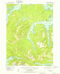
1951 Map of Craig B-2
USGS Topo · Published 1952About this map
The intricate fjords and forested peaks of Prince of Wales Island dominate this coastal survey, where the deep waters of Twelvemile Arm and Kasaan Bay meet the high ridges of Beaver Mountain. This era of the Alaskan panhandle reveals a landscape where maritime access dictated human activity, notably at Old Kasaan Nat Mon on the northern shore of Skowl Arm. The map documents the shifting tides of the local economy, noting the Sulzer (Aban'd) settlement and the Khayam Mine (Inactive) near McKenzie Inlet, both remnants of earlier copper and gold prospecting cycles.
Find a feature on this map
59 named features on this map. Tap any name to fly to it.
Don’t see what you’re looking for? This feature index may not catch every label — zoom into the map to look around manually.
Map Details
Editions of this 1951 Craig B-2 Map
2 editions found
Other maps of this area

1948 · Craig A-1
USGS Topo · 1:63,360

1948 · Craig A-3
USGS Topo · 1:63,360

1948 · Craig A-2
USGS Topo · 1:63,360

1949 · Craig C-2
USGS Topo · 1:63,360

1949 · Craig B-2
USGS Topo · 1:63,360

1949 · Craig B-3
USGS Topo · 1:63,360

1949 · Craig C-3
USGS Topo · 1:63,360

1949 · Craig B-1
USGS Topo · 1:63,360

1950 · Craig B-1
USGS Topo · 1:63,360

1950 · Craig C-1
USGS Topo · 1:63,360