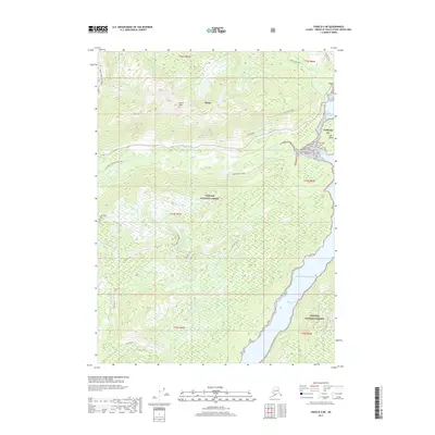
2017 Map of Craig B-3 NE
USGS Topo · Published 2017About this map
Hollis serves as the central hub of this coastal Alaskan landscape, situated where the Harris River meets the salt water of Harris River Bay. The map illustrates a complex network of forest access and historical routes, including Maybeso Road and the Twenty Mile Spur Trail, which traverse the dense timberlands of the Tongass National Forest. Evidence of the region's industrial past is seen at the High Dawson Mine, perched on the slopes above the bay. To the south, the deep inlet of Twelvemile Arm reaches into the interior, flanked by landmarks such as One Duck Lake and the summit of Harris Peak. The geography is defined by its maritime connections, from the sheltered Hollis Anchorage to the open Pacific Ocean, providing a detailed look at the infrastructure supporting this Prince of Wales Island community.
Find a feature on this map
33 named features on this map. Tap any name to fly to it.
Don’t see what you’re looking for? This feature index may not catch every label — zoom into the map to look around manually.
Map Details
Editions of this 2017 Craig B-3 NE Map
This is the sole edition of this map. No revisions or reprints were ever made.
Other maps of this area

1949 · Craig C-2
USGS Topo · 1:63,360

1949 · Craig B-2
USGS Topo · 1:63,360

1949 · Craig B-3
USGS Topo · 1:63,360

1949 · Craig C-3
USGS Topo · 1:63,360

1951 · Craig C-3
USGS Topo · 1:63,360

1951 · Craig B-2
USGS Topo · 1:63,360

1951 · Craig C-2
USGS Topo · 1:63,360

1951 · Craig B-3
USGS Topo · 1:63,360

1957 · Craig
USGS Topo · 1:250,000
1994 · Craig C-2
USGS Topo · 1:63,360