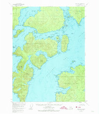
1948 Map of Craig B-5
USGS Topo · Published 1974About this map
Noyes Island and Lulu Island dominate this intricate maritime study of the Alexander Archipelago, where complex channels and sounds define the geography of the Tongass National Forest. The 1948 aerial survey data reveals a landscape of maritime navigation and isolation, noting features like the St Ignace Rock Light and the sheltered waters of Port Real Marina.
Find a feature on this map
106 named features on this map. Tap any name to fly to it.
Don’t see what you’re looking for? This feature index may not catch every label — zoom into the map to look around manually.
Map Details
Editions of this 1948 Craig B-5 Map
2 editions found
Other maps of this area

1948 · Craig A-4
USGS Topo · 1:63,360

1948 · Craig B-5
USGS Topo · 1:63,360

1948 · Craig A-5
USGS Topo · 1:63,360

1948 · Craig B-6
USGS Topo · 1:63,360

1949 · Craig C-4
USGS Topo · 1:63,360

1949 · Craig B-4
USGS Topo · 1:63,360

1951 · Craig C-6
USGS Topo · 1:63,360

1951 · Craig B-4
USGS Topo · 1:63,360

1951 · Craig C-4
USGS Topo · 1:63,360

1951 · Craig C-5
USGS Topo · 1:63,360