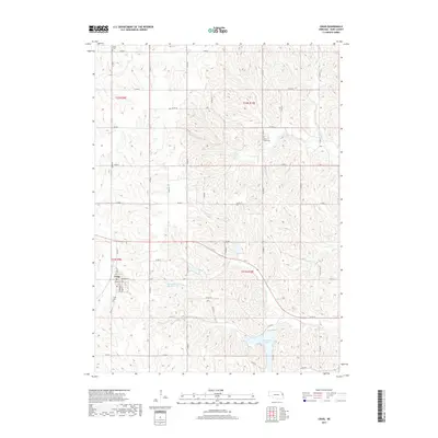
2017 Map of Craig
USGS Topo · Published 2017About this map
Craig serves as the central hub of this Burt County landscape, situated at the intersection of Main St and Morford Ave. The surrounding terrain is defined by a dense network of drainage systems, including the southward-flowing Silver Cr and Tekamah Cr. This 2017 survey reveals a rural landscape managed for water control, notably through the Tekamah Creek Reservoir 6-1 and the large expanse of Summit Lake in the southeast. Genealogists will find three distinct burial grounds across the townships: Craig Cem near the town site, Grace Cem in the northwest corner, and Silver Creek Cem overlooking its namesake waterway. The map provides a precise look at the township and range boundaries of t21n r10e and its neighbors, showing how the section lines and county roads have organized this agricultural region.
Find a feature on this map
41 named features on this map. Tap any name to fly to it.
Don’t see what you’re looking for? This feature index may not catch every label — zoom into the map to look around manually.
Map Details
Editions of this 2017 Craig Map
This is the sole edition of this map. No revisions or reprints were ever made.
Other maps of this area

1955 · Fremont
USGS Topo · 1:250,000

1957 · Fremont
USGS Topo · 1:250,000

1958 · Fremont
USGS Topo · 1:250,000

1966 · Oakland
USGS Topo · 1:24,000

1966 · Lyons
USGS Topo · 1:24,000

1966 · Nickerson NW
USGS Topo · 1:24,000

1970 · Oakland SE
USGS Topo · 1:24,000
1970 · Tekamah NW
USGS Topo · 1:24,000
1970 · Bertha
USGS Topo · 1:24,000

1970 · Herman
USGS Topo · 1:24,000