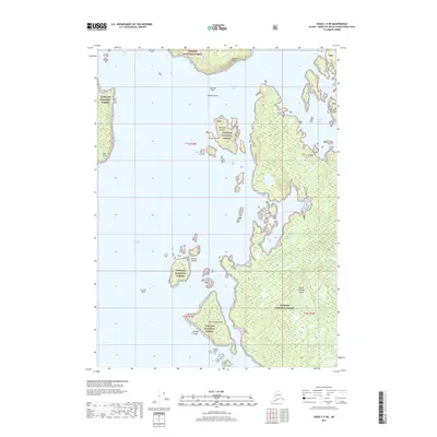
2017 Map of Craig C-5 NE
USGS Topo · Published 2017About this map
Prince of Wales Island is documented here in a landscape dominated by the protected coastal reaches of the Tongass National Forest. The map details a complex maritime environment characterized by narrow inlets and scattered island clusters, including the Harmony Islands and Culebra Islands. Shoreline navigation is anchored by named hazards and landmarks such as Curacao Reef, Phillips Rock, and the prominent Tonowek Ridge overlooking the water. The intricate waterway system, spanning from Warm Chuck Inlet in the north down to the Gulf of Esquibel, reveals the tidal character of Southeast Alaska, where features like Salt Lake Bay and Tonowek Bay define the interface between the dense forest and the Pacific.
Find a feature on this map
21 named features on this map. Tap any name to fly to it.
Don’t see what you’re looking for? This feature index may not catch every label — zoom into the map to look around manually.
Map Details
Editions of this 2017 Craig C-5 NE Map
This is the sole edition of this map. No revisions or reprints were ever made.
Other maps of this area

1949 · Craig D-4
USGS Topo · 1:63,360

1949 · Craig C-4
USGS Topo · 1:63,360

1951 · Craig C-4
USGS Topo · 1:63,360

1951 · Craig C-5
USGS Topo · 1:63,360

1951 · Craig D-5
USGS Topo · 1:63,360

1951 · Craig D-4
USGS Topo · 1:63,360

1957 · Craig
USGS Topo · 1:250,000
1994 · Craig D-4
USGS Topo · 1:63,360
1996 · Craig D-5
USGS Topo · 1:63,360
2017 · Craig C-5 NW
USGS Topo · 1:25,000