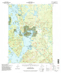
1994 Map of Craig D-4
USGS Topo · Published 1998About this map
Deweyville (Aban'd) stands as a reminder of the shifting timber and fishing settlements on Prince of Wales Island during the late twentieth century. Located within the Tongass National Forest, this map details the complex network of waterways including El Capitan Passage and Tuxekan Passage, which historically served as the primary transit routes before the expansion of logging roads. The landscape is dotted with active and historical sites of human activity, from the Naukati Bunkhouse (FS) and several Log Transfer Facilities to the Lighthouse Reserve and isolated Forest Service shelters like the Sarkar Lake Cabin (FS). Significant natural features such as Silver Salmon Falls and Horseshoe Hole reflect the region's rich aquatic environment, while the Staley Creek Bridge and portions of the Coffman Cove Road show the encroaching land-based infrastructure of the 1990s.
Find a feature on this map
96 named features on this map. Tap any name to fly to it.
Don’t see what you’re looking for? This feature index may not catch every label — zoom into the map to look around manually.
Map Details
Editions of this 1994 Craig D-4 Map
This is the sole edition of this map. No revisions or reprints were ever made.
Other maps of this area

1949 · Craig D-3
USGS Topo · 1:63,360

1949 · Petersburg A-3
USGS Topo · 1:63,360

1949 · Craig D-4
USGS Topo · 1:63,360

1949 · Petersburg A-5
USGS Topo · 1:63,360

1949 · Petersburg A-4
USGS Topo · 1:63,360

1949 · Craig C-3
USGS Topo · 1:63,360

1949 · Craig C-4
USGS Topo · 1:63,360

1950 · Craig D-3
USGS Topo · 1:63,360

1951 · Craig C-3
USGS Topo · 1:63,360

1951 · Craig C-4
USGS Topo · 1:63,360