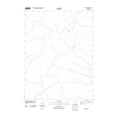
2010 Map of Craig NW
USGS Topo · Published 2010About this map
Industrial resource extraction defines the high-desert landscape of Moffat County on this 2010 topographic study. Scattered across the drainage of West Timberlake Creek and Blue Gravel Creek are several named mineral interests, including the Magpie Mine, Lay Mine, and Joker Mine. The presence of the Airborne Anomaly 56-12 Mine suggests modern geophysical prospecting methods utilized in this part of Colorado. A sparse network of county roads, such as County Rd-5 and County Rd-108, provides the primary access through this arid terrain, connecting these remote mining sites to the broader region. This map illustrates the intersection of traditional mining interests with 21st-century infrastructure in the western United States.
Find a feature on this map
11 named features on this map. Tap any name to fly to it.
Don’t see what you’re looking for? This feature index may not catch every label — zoom into the map to look around manually.
Map Details
Editions of this 2010 Craig NW Map
This is the sole edition of this map. No revisions or reprints were ever made.
Other maps of this area

1916 · Craig
USGS Topo · 1:125,000

1954 · Craig
USGS Topo · 1:250,000

1957 · Craig
USGS Topo · 1:250,000

1958 · Craig
USGS Topo · 1:250,000

1960 · Craig
USGS Topo · 1:250,000

1962 · Craig
USGS Topo · 1:250,000

1964 · Craig
USGS Topo · 1:250,000

1965 · Craig
USGS Topo · 1:250,000
1969 · Great Divide
USGS Topo · 1:24,000
1969 · Fortification
USGS Topo · 1:24,000