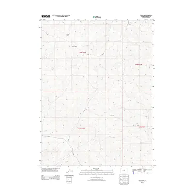
2013 Map of Craig NW
USGS Topo · Published 2013About this map
Housel Gulch and Dressler Gulch define the high-plateau drainage systems of this Moffat County landscape. This 2013 survey illustrates a sparsely populated region northwest of Craig where the land is primarily organized by its hydrography and public land survey boundaries. Narrow watercourses like Blue Gravel Cr and W Timberlake Cr cut through the terrain, while a network of county roads, including CO Road 108 and CO Road 7, provide the only modern access through the open range. The map clearly delineates the township and range lines, such as the boundary between t009n r092w and t009n r091w, which historically dictated grazing and mineral rights in the Colorado high country.
Find a feature on this map
14 named features on this map. Tap any name to fly to it.
Don’t see what you’re looking for? This feature index may not catch every label — zoom into the map to look around manually.
Map Details
Editions of this 2013 Craig NW Map
This is the sole edition of this map. No revisions or reprints were ever made.
Other maps of this area

1916 · Craig
USGS Topo · 1:125,000

1954 · Craig
USGS Topo · 1:250,000

1957 · Craig
USGS Topo · 1:250,000

1958 · Craig
USGS Topo · 1:250,000

1960 · Craig
USGS Topo · 1:250,000

1962 · Craig
USGS Topo · 1:250,000

1964 · Craig
USGS Topo · 1:250,000

1965 · Craig
USGS Topo · 1:250,000
1969 · Great Divide
USGS Topo · 1:24,000
1969 · Fortification
USGS Topo · 1:24,000