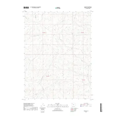
2019 Map of Craig NW
USGS Topo · Published 2019About this map
North Fork Big Gulch and its tributaries carve a complex drainage pattern across this high desert landscape in northwestern Colorado. The terrain is defined by a dense network of coulees and ridges, where seasonal watercourses like Blue Gravel Cr and W Timberlake Cr have eroded the plateau. Settlement is sparse, characterized by a grid of rural routes including Co Rd 5 and Co Rd 3 that follow the section lines and topography of the Public Land Survey System. The map documents the persistent naming of minor topographic features such as Dressler Gulch and Housel Gulch, which serve as vital landmarks in an otherwise repeating landscape of sagebrush and scrub. This 2019 survey captures the area's transition between the rolling hills of the Great Divide and the deeper incisions of the regional gulch systems.
Find a feature on this map
13 named features on this map. Tap any name to fly to it.
Don’t see what you’re looking for? This feature index may not catch every label — zoom into the map to look around manually.
Map Details
Editions of this 2019 Craig NW Map
This is the sole edition of this map. No revisions or reprints were ever made.
Other maps of this area

1916 · Craig
USGS Topo · 1:125,000

1954 · Craig
USGS Topo · 1:250,000

1957 · Craig
USGS Topo · 1:250,000

1958 · Craig
USGS Topo · 1:250,000

1960 · Craig
USGS Topo · 1:250,000

1962 · Craig
USGS Topo · 1:250,000

1964 · Craig
USGS Topo · 1:250,000

1965 · Craig
USGS Topo · 1:250,000
1969 · Great Divide
USGS Topo · 1:24,000
1969 · Fortification
USGS Topo · 1:24,000