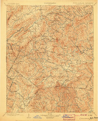
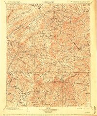
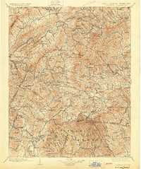
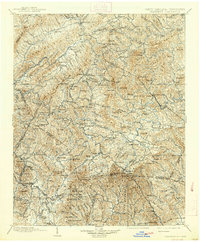
1902 Map of Cranberry
USGS Topo · Published 1907About this map
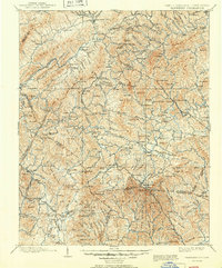
Mountain City serves as a primary hub within this highland region during the late nineteenth-century surveying period, situated where Roane Creek meets several mountain passes. The landscape is defined by the high peaks of Grandfather Mt and Beech Mountain, creating a complex network of ridges and gaps that dictated early settlement patterns. Transportation was undergoing a significant shift as the Virginia and Southwestern RR and the Linville River Ry began to pierce the rugged topography, supplementing established routes like the Yonahlossee Road. Researchers can identify numerous small communities and industrial sites, such as Rhea Forge and Elk Mills, which were central to the local economy. The map also captures the distinct boundary between North Carolina and Tennessee, winding through gaps like Zionville and Trade, documenting a period when these mountain gaps were the vital lifelines for commerce and movement between Watauga and Johnson counties.
Find a feature on this map
198 named features on this map. Tap any name to fly to it.
Don’t see what you’re looking for? This feature index may not catch every label — zoom into the map to look around manually.
Map Details
Editions of this 1902 Cranberry Map
6 editions found

Other maps of this area

1889 · Wytheville
USGS Topo · 1:125,000

1889 · Wilkesboro
USGS Topo · 1:125,000

1891 · Roan Mountain
USGS Topo · 1:125,000

1891 · Abingdon
USGS Topo · 1:125,000

1891 · Wilkesboro
USGS Topo · 1:125,000

1892 · Wytheville
USGS Topo · 1:125,000

1893 · Cranberry
USGS Topo · 1:125,000

1894 · Roan Mountain
USGS Topo · 1:125,000

1894 · Abingdon
USGS Topo · 1:125,000

1895 · Hickory
USGS Topo · 1:125,000