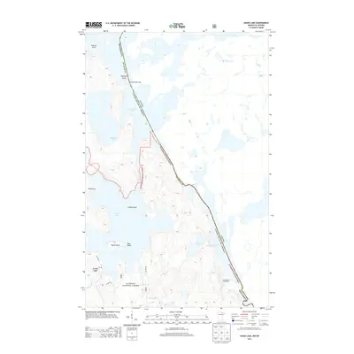
2013 Map of Crane Lake
USGS Topo · Published 2013About this map
Sand Point Lake and the winding international boundary between Minnesota and Canada dominate this 2013 topographic survey of the Boundary Waters region. The settlement of Crane Lake serves as a focal point at the edge of the Superior National Forest, where the transition from road access at Hilltop Rd and Bayside Dr gives way to a vast water-and-island landscape. The mapping details the intricate shoreline of Little Vermilion Lake and Mukooda Lake, alongside prominent landforms like Wolf Point and Harrison Narrows. This era of the landscape is marked by the preservation of wild spaces, with the Sand Beach Campground and various island features like Bear Island and Indian Island illustrating the area's importance for recreational water travel. Local hydrology is further defined by the Echo River and Camp Forty Cr feeding into the larger lake systems.
Find a feature on this map
25 named features on this map. Tap any name to fly to it.
Don’t see what you’re looking for? This feature index may not catch every label — zoom into the map to look around manually.
Map Details
Editions of this 2013 Crane Lake Map
This is the sole edition of this map. No revisions or reprints were ever made.
Other maps of this area

1954 · International Falls
USGS Topo · 1:250,000

1957 · International Falls
USGS Topo · 1:250,000

1958 · International Falls
USGS Topo · 1:250,000

1963 · Echo Lake
USGS Topo · 1:24,000

1963 · Snow Bay
USGS Topo · 1:24,000

1963 · Redhorse Bay
USGS Topo · 1:24,000

1963 · Lake Jeanette
USGS Topo · 1:24,000

1963 · Crane Lake
USGS Topo · 1:24,000

1967 · Kabustasa Lake
USGS Topo · 1:24,000

1967 · Hale Bay
USGS Topo · 1:24,000