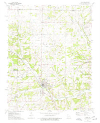
1974 Map of Crane
USGS Topo · Published 1977About this map
The Missouri Pacific railroad corridor anchors this mid-1970s study of the Crane area, where the tracks follow the winding valley of Crane Creek. The terrain is defined by a complex network of hollows, including McCullah Hollow and Hilton Hollow, which drain into the larger creek systems. For genealogists, the map is particularly detailed regarding local burial sites and places of worship, marking the Masonic Cem, Oak Grove Cem, and Hood Cem, alongside rural congregations like Pierson Ch and Shiloh Ch. The landscape reveals a transition from the structured street grid of Crane and its City Park to the dispersed settlements at Browns Spring and Hurley. Notable landmarks such as Rickman Spring and an Old RR Grade suggest the historical importance of water resources and previous rail infrastructure in shaping this part of Stone County.
Find a feature on this map
44 named features on this map. Tap any name to fly to it.
Don’t see what you’re looking for? This feature index may not catch every label — zoom into the map to look around manually.
Map Details
Editions of this 1974 Crane Map
This is the sole edition of this map. No revisions or reprints were ever made.
Other maps of this area

1884 · Springfield
USGS Topo · 1:125,000

1886 · Greenfield
USGS Topo · 1:125,000

1886 · Springfield
USGS Topo · 1:125,000

1888 · Greenfield
USGS Topo · 1:125,000

1907 · Forsyth
USGS Topo · 1:125,000

1919 · Halltown
USGS Topo · 1:62,500

1942 · Aurora
USGS Topo · 1:62,500

1945 · Harrison
USGS Topo · 1:250,000

1945 · Aurora
USGS Topo · 1:62,500

1949 · Harrison
USGS Topo · 1:250,000