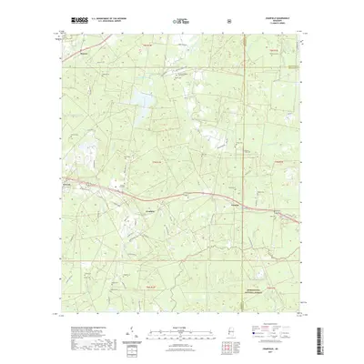
2021 Map of Cranfield
USGS Topo · Published 2021About this map
Cranfield and Leesdale serve as central points in this rural landscape at the crossroads of Old Hwy 84 and Old Hwy 84 No 4. The map reveals a dense distribution of family and community burial grounds, such as Hoggatt Cem, Roaring Dale Cem, and Pry Temple Baptist Church Cem, suggesting a long-standing pattern of family land ownership and religious activity. The southern portion is defined by the Homochitto National Forest, where the terrain is carved by the drainages of Sandy Creek and Bates Creek. To the northwest, the settlement of Stanton lies near the headwaters of Whitens Creek. This 2021 update records the modern road network, from major corridors like State Park Rd to smaller residential lanes like Miracle Rd, while still documenting the enduring sites of local heritage and the rugged hydrology of the Adams County and Franklin County border.
Find a feature on this map
76 named features on this map. Tap any name to fly to it.
Don’t see what you’re looking for? This feature index may not catch every label — zoom into the map to look around manually.
Map Details
Editions of this 2021 Cranfield Map
This is the sole edition of this map. No revisions or reprints were ever made.
Other maps of this area

1921 · Natchez
USGS Topo · 1:48,000

1922 · Natchez
USGS Topo · 1:62,500

1939 · Natchez
USGS Topo · 1:62,500

1939 · Kingston
USGS Topo · 1:62,500

1953 · Natchez
USGS Topo · 1:250,000

1956 · Natchez
USGS Topo · 1:250,000

1958 · Kingston
USGS Topo · 1:62,500

1959 · Natchez
USGS Topo · 1:250,000

1961 · Crosby
USGS Topo · 1:62,500

1962 · Fayette
USGS Topo · 1:62,500