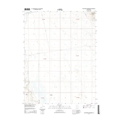
2014 Map of Crater Bench Reservoir
USGS Topo · Published 2014About this map
Desert Mtn rises above the arid Juab County landscape, anchoring a region defined by ancient hydrologic patterns and desert transport routes. This 2014 survey highlights the Old River Bed, a significant geological feature that winds through the center of the quadrangle, serving as a reminder of the prehistoric waterways that once carved this terrain. Human intervention in this water-scarce environment is evidenced by the presence of the River Bed Reservoir and the Crater Bench Reservoir, both positioned to capture seasonal runoff. In the southwest, the Baker Hot Spgs road suggests the location of thermal activity near the base of Crater Bench. A sparse network of infrastructure including Weiss Hwy and Melvins Mine Rd provides access to the remote interior, while Cherry Creek Wash cuts through the southern flats, marking the primary drainage for the surrounding basins.
Find a feature on this map
17 named features on this map. Tap any name to fly to it.
Don’t see what you’re looking for? This feature index may not catch every label — zoom into the map to look around manually.
Map Details
Editions of this 2014 Crater Bench Reservoir Map
This is the sole edition of this map. No revisions or reprints were ever made.
Other maps of this area

1885 · Sevier Desert
USGS Topo · 1:250,000

1953 · Delta
USGS Topo · 1:250,000

1958 · Delta
USGS Topo · 1:250,000

1962 · Delta
USGS Topo · 1:250,000

1971 · Baker Hot Springs
USGS Topo · 1:24,000

1971 · Rain Lake
USGS Topo · 1:24,000

1971 · Desert Mtn Pass
USGS Topo · 1:24,000

1971 · Crater Bench Reservoir
USGS Topo · 1:24,000
1971 · Keg Mtn Ranch
USGS Topo · 1:24,000

1971 · Fumarole Butte
USGS Topo · 1:24,000