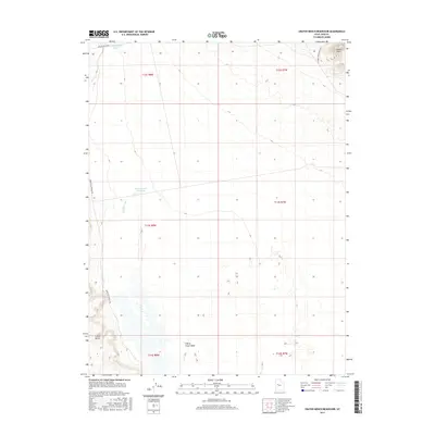
2017 Map of Crater Bench Reservoir
USGS Topo · Published 2017About this map
Desert Mtn rises from the arid floor of Juab County, anchoring a landscape shaped by ancient water systems and remote thoroughfares. The topographical detail reveals the distinct elevation of the Crater Bench volcanic formation, which sits adjacent to the meandering course of the Old River Bed. This natural channel, once a prehistoric waterway, now defines the drainage patterns through the central portion of the quadrangle. Sparse water resources are captured in man-made catchments like the River Bed Reservoir and the Crater Bench Reservoir, illustrating the human adaptation to this dry desert environment.
Find a feature on this map
15 named features on this map. Tap any name to fly to it.
Don’t see what you’re looking for? This feature index may not catch every label — zoom into the map to look around manually.
Map Details
Editions of this 2017 Crater Bench Reservoir Map
This is the sole edition of this map. No revisions or reprints were ever made.
Other maps of this area

1885 · Sevier Desert
USGS Topo · 1:250,000

1953 · Delta
USGS Topo · 1:250,000

1958 · Delta
USGS Topo · 1:250,000

1962 · Delta
USGS Topo · 1:250,000

1971 · Baker Hot Springs
USGS Topo · 1:24,000

1971 · Rain Lake
USGS Topo · 1:24,000

1971 · Desert Mtn Pass
USGS Topo · 1:24,000

1971 · Crater Bench Reservoir
USGS Topo · 1:24,000
1971 · Keg Mtn Ranch
USGS Topo · 1:24,000

1971 · Fumarole Butte
USGS Topo · 1:24,000