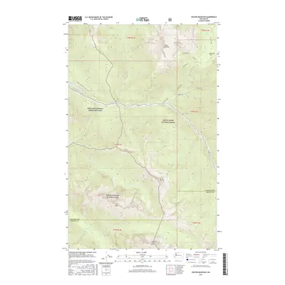
2017 Map of Crater Mountain
USGS Topo · Published 2017About this map
Crater Ridge and the soaring peak of Crater Mountain dominate the northern landscape of this Cascades survey, where alpine meadows and high-elevation parklands like McMillan Park meet the rugged drainage basins of the Whatcom and Skagit county line. The map captures a complex intersection of protected lands, spanning the Ross Lake National Recreation Area, Mount Baker National Forest, and North Cascades National Park. The Pacific NW National Scenic Trail traverses the western slopes above Ross Lake, following the contours of the land near Ruby Arm. To the south, the deep valleys of Panther Cr and Gabriel Cr carve through the wilderness between Elija Ridge and Gabriel Peak, illustrating the dramatic verticality of the North Cascades. The historic route of Chancellor winds along Ruby Cr, providing a trace of the area's prospecting and backcountry travel history.
Find a feature on this map
33 named features on this map. Tap any name to fly to it.
Don’t see what you’re looking for? This feature index may not catch every label — zoom into the map to look around manually.
Map Details
Editions of this 2017 Crater Mountain Map
This is the sole edition of this map. No revisions or reprints were ever made.
Other maps of this area

1920 · Slate Pass
USGS Topo · 1:125,000

1955 · Concrete
USGS Topo · 1:250,000

1958 · Concrete
USGS Topo · 1:250,000

1962 · Concrete
USGS Topo · 1:250,000

1963 · Azurite Peak
USGS Topo · 1:24,000
1963 · Mt. Arriva
USGS Topo · 1:24,000
1963 · Forbidden Peak
USGS Topo · 1:24,000
1963 · Mt Logan
USGS Topo · 1:24,000

1963 · Crater Mountain
USGS Topo · 1:24,000

1963 · Ross Dam
USGS Topo · 1:24,000