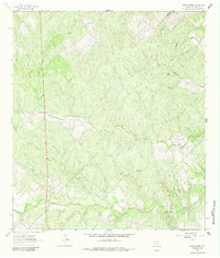
1963 Map of Crater Ridge
USGS Topo · Published 1964About this map
Petroleum and ranching infrastructure define this corner of Live Oak County in the early 1960s. The landscape is marked by the Burnett Oil and Gas Field, alongside the McNeil Oil Field and McNeil South Oil Field, illustrating the intensive mineral extraction of the era. These industrial sites are interspersed with family-named water sources essential for livestock, such as Jacobs Tank and Jacobs Windmill.
Find a feature on this map
17 named features on this map. Tap any name to fly to it.
Don’t see what you’re looking for? This feature index may not catch every label — zoom into the map to look around manually.
Map Details
Editions of this 1963 Crater Ridge Map
2 editions found
Other maps of this area

1920 · Mikeska
USGS Topo · 1:125,000

1925 · Oakville No. 4
USGS Topo · 1:48,000

1925 · Mathis No. 2
USGS Topo · 1:48,000

1925 · Mathis No. 3
USGS Topo · 1:48,000

1927 · Mathis
USGS Topo · 1:62,500

1927 · Oakville
USGS Topo · 1:62,500

1953 · Crystal City
USGS Topo · 1:250,000

1953 · Beeville
USGS Topo · 1:250,000

1954 · Fleming
USGS Topo · 1:62,500

1954 · Mathis
USGS Topo · 1:62,500