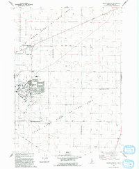
1992 Map of Crater Rings SE
USGS Topo · Published 1992About this map
The Mountain Home Air Force Base Small Arms Range dominates the high desert landscape of Elmore County in the early 1990s. This survey illustrates a specialized military and conservation corridor where the sprawling Snake River Birds of Prey Area overlaps with defense infrastructure. The base facilities are shown in detail, including the Hospital, a Golf Course, and an Athletic Field, alongside a network of local streets such as Venado Lane and Main Ave.
Find a feature on this map
25 named features on this map. Tap any name to fly to it.
Don’t see what you’re looking for? This feature index may not catch every label — zoom into the map to look around manually.
Map Details
Editions of this 1992 Crater Rings SE Map
This is the sole edition of this map. No revisions or reprints were ever made.
Other maps of this area

1892 · Mountain Home
USGS Topo · 1:125,000

1893 · Mountain Home
USGS Topo · 1:125,000

1946 · Mouth of Bruneau
USGS Topo · 1:24,000

1947 · Bruneau
USGS Topo · 1:62,500

1947 · Sand Dunes
USGS Topo · 1:24,000

1947 · Bruneau
USGS Topo · 1:24,000

1948 · Sand Dunes
USGS Topo · 1:24,000
1948 · Bruneau
USGS Topo · 1:24,000

1948 · Indian Cove
USGS Topo · 1:62,500
1949 · Mouth of Bruneau
USGS Topo · 1:24,000