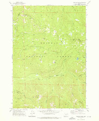
1972 Map of Crawfish Lake
USGS Topo · Published 1976About this map
The high backcountry of the Whitman National Forest in the early 1970s reveals a landscape defined by its mining heritage and rugged water systems. Situated along the boundary between Union and Grant counties, this area includes the settlement of Cabell City and numerous subterranean workings. High-elevation extraction points such as the Continental Mine, Standard Mine, and Labellevue Mine are connected by a network of jeep trails and pack trails, indicating the persistent industrial interest in these mountains.
Find a feature on this map
39 named features on this map. Tap any name to fly to it.
Don’t see what you’re looking for? This feature index may not catch every label — zoom into the map to look around manually.
Map Details
Editions of this 1972 Crawfish Lake Map
2 editions found
Other maps of this area

1901 · Sumpter
USGS Topo · 1:125,000

1953 · Pendleton
USGS Topo · 1:250,000

1955 · Canyon City
USGS Topo · 1:250,000

1956 · Pendleton
USGS Topo · 1:250,000

1959 · Canyon City
USGS Topo · 1:250,000

1965 · Limber Jim Creek
USGS Topo · 1:24,000

1965 · Anthony Butte
USGS Topo · 1:24,000

1965 · Fly Valley
USGS Topo · 1:24,000

1972 · Trout Meadows
USGS Topo · 1:24,000

1972 · Mt. Ireland
USGS Topo · 1:24,000