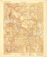
1916 Map of Creede
USGS Topo · Published 1916About this map
Mining activity and high-altitude settlements dominate the landscape of the San Juan Mountains in the years following the silver boom. The town of Creede serves as a central hub, connected by the Denver and Rio Grande railroad to outlying mining districts like Bachelor and Sunnyside. To the southwest, the remote Spar City sits near the Emma Mine, illustrating the reach of mineral exploration into the steep canyons.
Find a feature on this map
108 named features on this map. Tap any name to fly to it.
Don’t see what you’re looking for? This feature index may not catch every label — zoom into the map to look around manually.
Map Details
Editions of this 1916 Creede Map
3 editions found
Other maps of this area

1905 · San Cristobal
USGS Topo · 1:125,000

1907 · San Cristobal
USGS Topo · 1:125,000

1908 · Uncompahgre
USGS Topo · 1:125,000

1911 · Uncompahgre
USGS Topo · 1:125,000

1913 · Summitville
USGS Topo · 1:125,000

1914 · Creede
USGS Topo · 1:125,000

1915 · Summitville
USGS Topo · 1:125,000

1915 · Del Norte
USGS Topo · 1:125,000

1916 · Creede
USGS Topo · 1:125,000

1917 · Del Norte
USGS Topo · 1:125,000